13th Kayak Outing
Three days and 2 nights of rustic kayak-camping at l'Equerre camping at the Hautes-Gorges-de-la-Rivière-Malbaie National Park. See post below for link to SEPAQ site describing this jewel of a park.
As impressive as the Saguenay Fjord can be (particularly with all the seals & whales), les Hautes-Gorges is in many ways more spectacular. The escarpments of les Hautes Gorges are higher & steeper and the valley is narrower. You really feel like a tiny dot floating on the 5 mile long reservoir between the dam and l'Equerre (T-Square: a 90 degree bend in the river/valley).
You can clearly see the "7" shaped river in the top left corner of the map below.

The following view with contour lines shows just how steep & narrow the valley really is.

And here is a Google Earth view from l'Equerre

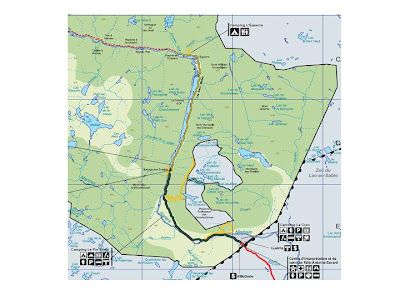
Vehicles aren't usually permitted in the park, see map below (click to enlarge). You drive in (red line) leave your vehicle at Parking #6, register & a shuttle with a trailer picks up your kayaks, equipment and drives you (along green line) to the dam near the put-in.

There are three campsites in the park. Camping Le Cran is near the park entrance, Camping Pin Blanc is by the river below the dam (rapids therefore not the best place for kayaks & canoes), and Camping de l'Equerre is on the reservoir created by the dam, about as far as you can go before reaching the first set of rapids.

It's about 5 miles from the put-in (by the kayak/canoe rental cabin) to the Equerre camping. L'Equerre is a rustic campsite with two-dozen sites large enough for one tent. Only a few have direct access to the river, which means that if you're staying at one of the others sites, you have to park at the beach and hike up your stuff up to your sites. We had the left-most site on the river-side of the access road. This road is used by hikers & bikers (and parc maintenance vehicles). Otherwise everyone else paddles in.

The kayaking was great, and we really enjoyed this fabulous experience.


Three days and 2 nights of rustic kayak-camping at l'Equerre camping at the Hautes-Gorges-de-la-Rivière-Malbaie National Park. See post below for link to SEPAQ site describing this jewel of a park.
As impressive as the Saguenay Fjord can be (particularly with all the seals & whales), les Hautes-Gorges is in many ways more spectacular. The escarpments of les Hautes Gorges are higher & steeper and the valley is narrower. You really feel like a tiny dot floating on the 5 mile long reservoir between the dam and l'Equerre (T-Square: a 90 degree bend in the river/valley).
You can clearly see the "7" shaped river in the top left corner of the map below.

The following view with contour lines shows just how steep & narrow the valley really is.

And here is a Google Earth view from l'Equerre

Vehicles aren't usually permitted in the park, see map below (click to enlarge). You drive in (red line) leave your vehicle at Parking #6, register & a shuttle with a trailer picks up your kayaks, equipment and drives you (along green line) to the dam near the put-in.

There are three campsites in the park. Camping Le Cran is near the park entrance, Camping Pin Blanc is by the river below the dam (rapids therefore not the best place for kayaks & canoes), and Camping de l'Equerre is on the reservoir created by the dam, about as far as you can go before reaching the first set of rapids.

It's about 5 miles from the put-in (by the kayak/canoe rental cabin) to the Equerre camping. L'Equerre is a rustic campsite with two-dozen sites large enough for one tent. Only a few have direct access to the river, which means that if you're staying at one of the others sites, you have to park at the beach and hike up your stuff up to your sites. We had the left-most site on the river-side of the access road. This road is used by hikers & bikers (and parc maintenance vehicles). Otherwise everyone else paddles in.

The kayaking was great, and we really enjoyed this fabulous experience.


